A) lower at lower altitude
B) lower at higher altitude
C) highest when the wind is blowing
D) lowest when the wind is blowing
Correct Answer

verified
Correct Answer
verified
Multiple Choice
Wind moves sediment by:
A) bouncing sand grains along the surface
B) rolling sand grains along the surface
C) carrying finer material,like dust and silt,in air currents
D) all of these
Correct Answer

verified
Correct Answer
verified
Multiple Choice
Most equatorial regions are warmer than the rest of Earth because of:
A) Earth's daily rotation
B) Earth's orbit around Sun
C) tilt of Earth's axis of rotation
D) none of these
Correct Answer

verified
Correct Answer
verified
Multiple Choice
The area marked by number 2 on this figure is a desert primarily because: 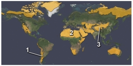
A) it is in the rainshadow of a mountain range
B) it is cooled by cold currents from the Arctic
C) it is within the interior of a continent
D) it experiences dry,descending air in the subtropics
Correct Answer

verified
Correct Answer
verified
Multiple Choice
For these ocean currents in the South Atlantic,which of these currents is mostly likely to be a cold current? 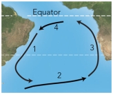
A) 1
B) 3
C) 4
D) both 1 and 3
E) both 2 and 4
Correct Answer

verified
Correct Answer
verified
Multiple Choice
What factors caused hurricanes in 2004 to strike the U.S.?
A) a ridge of high pressure kept hurricanes in the Atlantic from turning north
B) winds guided hurricanes toward Florida
C) warmer-than-average water off Florida helped sustain the hurricanes
D) all of these
Correct Answer

verified
Correct Answer
verified
Multiple Choice
Which of the following sites on this figure contains a desert? 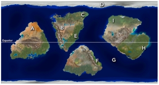
A) A
B) C
C) E
D) F
E) H
Correct Answer

verified
Correct Answer
verified
Multiple Choice
What topic was NOT discussed in the opening of the climate chapter?
A) the monsoon of India
B) the role of the Himalaya in climate
C) the Brahmaputra River of India and Bangladesh
D) all of these were discussed
Correct Answer

verified
Correct Answer
verified
Multiple Choice
Based on data collected in Hawaii,since about 1960 the amount of CO2 in the atmosphere has:
A) decreased as more trees are cut down
B) increased and then decreased
C) decreased and then increased
D) consistently increased,except for yearly variations
Correct Answer

verified
Correct Answer
verified
Multiple Choice
This diagram shows the conditions under which the three phases of water can exist.Which of the following is NOT true? 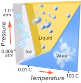
A) increasing temperature can cause ice to become liquid
B) increasing temperature can cause liquid to become vapor
C) at low pressure,increasing temperature can cause ice to become vapor
D) decreasing pressure can convert vapor to ice or a liquid
Correct Answer

verified
Correct Answer
verified
Multiple Choice
Which of the following landscape features is NOT common in deserts?
A) alluvial fan
B) playa
C) rock varnish
D) dry wash
E) all of these are common in deserts
Correct Answer

verified
Correct Answer
verified
Multiple Choice
The thermohaline conveyor is driven by:
A) warm,less saline surface water that circulates at the equator
B) cold less saline water that flows from melting glaciers in Greenland
C) warmer surface water that rises in the Indian Ocean
D) warm saline water that sinks in the North Atlantic
E) warm deep water that rises in the North Pacific
Correct Answer

verified
Correct Answer
verified
Multiple Choice
This figure shows warmer-than-normal sea-surface temperatures in the western Pacific and cooler-than-normal temperatures for the eastern Pacific.What condition is being illustrated? 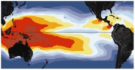
A) monsoon
B) world-wide drought
C) El Niño
D) La Niña
Correct Answer

verified
Correct Answer
verified
Multiple Choice
This diagram suggests that: 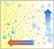
A) ice crystals can form across a range of temperatures at higher altitudes
B) water droplets form across a range of temperatures
C) while rain is failing at lower elevations,ice crystals can exist at higher elevations
D) all of these
E) none of these
Correct Answer

verified
Correct Answer
verified
Multiple Choice
Which of the following is true about a feature that develops in desert landscapes?
A) an alluvial fan forms where a river terrace steepens toward the channel
B) a desert wash typically has some water throughout the year
C) a playa is a gently sloping erosion surface
D) desert pavement takes thousands of years to develop
E) none of these
Correct Answer

verified
Correct Answer
verified
Multiple Choice
What is the main setting in which rain forests occur?
A) near the equator
B) at 30 north and 30 south latitude
C) at 45 north and 45 south latitude
D) in the interior of large continents,especially Asia
Correct Answer

verified
Correct Answer
verified
Multiple Choice
This graph shows an interpretation of temperatures based on the change in isotopes in ice-core data.This graph implies that: 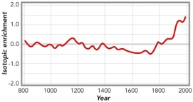
A) current temperatures are by far the hottest based on this record
B) atmospheric warming started as early as the late 1700s
C) the coolest time period on this data set was from around 1500 to the last part of the 1700s
D) all of these
Correct Answer

verified
Correct Answer
verified
Multiple Choice
Dust storms,like the one shown in this satellite image near North Africa,can transport dust over maximum distances of: 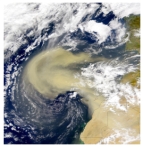
A) 10 kilometers
B) 50 to 90 kilometers
C) 100 kilometers because of the Coriolis effect
D) several hundred kilometers
E) thousands of kilometers
Correct Answer

verified
Correct Answer
verified
Multiple Choice
Which of the following is true about a feature that develops in desert landscapes?
A) a pediment is a steep surface cut onto unconsolidated sediment
B) rocks can become concentrated on desert surfaces,forming desert pavement
C) caliche is not common in desert soils
D) desert varnish is a dark coating applied to the rocks by Native Americans
E) all of these are true about features that develop in deserts
Correct Answer

verified
Correct Answer
verified
Multiple Choice
The Coriolis effect in this figure shows the deflection of cold air as it rushes in to replace hot rising air above a low pressure zone.The Coriolis effect: 
A) usually is evident in local small storms less than a few kilometers wide
B) is responsible for tornados and whirlwinds
C) requires a very large air masses since it requires defection by the Earth's rotation
D) is seen in smoke rising from a building fire
E) all of these
Correct Answer

verified
Correct Answer
verified
Showing 21 - 40 of 85
Related Exams